This map is “A Chart of Part of the Interior of New South Wales by John Oxley, Surveyor General 1817 First Expedition.” Published in England 15 March 1820 and which I purchased in Edinburgh in 1977. The Australian Encyclopaedia refers to it as an “historic map and is esteemed for being the pioneer production in that particular branch of Australian cartography”. This is said to be the first map of inland NSW ever sold to the public. The Lachlan River was first explored in 1817 by John Oxley(1784 – 1828) , NSW Surveyor General and explorer, well known for his role in our early colonial history and his early NSW expedition maps.
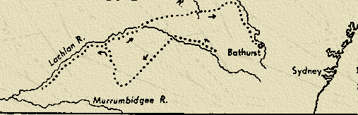
During Governor Macquarie’s administration Oxley was as much occupied with exploring as surveying. In 1815 his assistant, George Evans, discovered the Lachlan River and reported good country south-west of Bathurst. In March 1817 Macquarie appointed Oxley to lead an expedition to explore this region and if possible ‘to ascertain the real course … of the Lachlan … and whether it falls into the sea, or into some inland lake’. Leaving Bathurst on 28 April the explorers followed the Lachlan for more than two months until in July impassable marshes prevented further progress. Oxley then struck northward to the Macquarie River, which he traced back to Bathurst, where he arrived on 29 August. Macquarie highly praised Oxley’s ‘Zealous, Indefatigable and Intelligent Exertions’ and recommended that he be given £200 for his ‘Meritorious Services’, which the secretary of state approved.[Australian Dictionary of Biography]
Exploring the Lachlan: Once the Blue Mountains had been crossed in 1813, and the town of Bathurst established, the colony wished to expand. Wool had become Australia’s first main industry and more land was needed for sheep. In 1817, Oxley set off to explore the country west of Bathurst. Evans had discovered the Lachlan River and so Oxley set off to explore this river. Some of the party rode horses while others travelled in boats. They had taken with them salted meat and at the end of each day’s journey would camp and go fishing. This provided a change from the salted food. Tall thick grass made the going very difficult and eventually they found their way was blocked by marshes. Leaving their boats, they started off south west and came across very dry country. The horses became very weak and started to die. The men were forced to eat dingo, emu and snake.
The explorers turned north west and again came across the Lachlan. They continued downstream until they were again blocked again by marshes, causing them to turn back. Oxley believed that the interior was marshland and unsuitable for settlement. Little did he know that he was a few days away from the Murrumbidgee and large areas of good land. Food was running low, so he returned to Bathurst.
[David Reilly – Australian Explorers.]