The story is still in preparation. In the meantime some detail and photographs below.
See also other Darbys Falls items, including Gordon Elliott’s account, as well as Margaret Harris’ Diary, in the Index to the right.

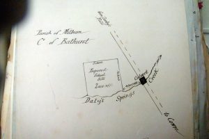
The location of the original Darbys Falls on the Lachlan River on the bottom right of the map, near the junction with Milburn Creek. The land there was settled there by the Jordan and Markham families in the early 1830s. The first Post Office was established by the Jordans in 1875. Darbys Falls was moved to ‘Daley’s Springs’ in the top left hand of the map in about 1885.
Present day Darbys Falls is noted on the upper left side of this cadastral map. However this location dates only from the mid 188os when the Darbys Falls school was established at the site of Daley’s Springs. The original Darbys Falls is also noted on this map….in the lower right hand corner near the junction of Milburn creek and the Lachlan River.
The First Darbys Fall or Falls.
The first of the two early settlers at and around the site of the first Darbys Falls was Edmund Markham (1802 -1866)(“Mangles” 1822) in the very early 1830s. The precise date and circumstances are unknown though it is likely that he arrived there in 1830 shortly after resigning his short membership of the Sydney Police. The other early settler, at about the same time was Nicholas Jordan (1795-1871)(“Boyne” 1826) who later, probably after 1841, took up land in his own name surrounding the area set aside for a “Village Reserve” (See Box below) This is the area which later was designated Darbys Falls. See “Who was first – Jordan or Markham?”
The earliest reference I have found to the location, described as Darbys Fall, not Falls, was in the Bathurst Free Press of 14 November 1861, referring to the area of the junction of Milburn Creek with the Lachlan River.:“……….at the lower end where the two channels join again, the River can be crossed with a dray at what is called Darby’s Fall. The banks are very straight and steep, probably some 25 or 30 feet. “

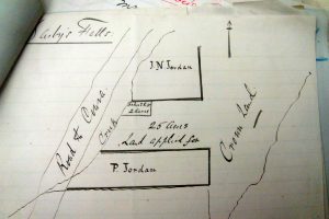
Richards Survey 3 Oct 1840 (Book 456 NSW Archives AO2/5073)
While there is no evidence that any Crown facilities were erected there, it appears to have been the point where travellers could cross the Lachlan. The origin of the name is unknown, though the use of the term “Darbys Fall” may suggest a fall from the so called cliff opposite the crossing. On the other hand, the term “Darbys Falls” suggests a waterfall, a feature not evident there today?Nicholas Jordan’s eldest son J N J Jordan, (1833-1917) and born on Milburn Creek, and whose home was adjacent to the crossing, was the first postmaster. My father wrote some years ago that “….he was the first Postmaster and that the Post Office was opened at the Rusty Hut on July 1st 1875 and later moved to what is known as ‘Jack Anthony’s Place”.”
The only other reference to Jordan as Postmaster or to the Post Office, was the Bathurst Free Press in 1878 reporting a case re money stolen by a local youth from mail originating from Jordan’s Darbys Falls Post Office.
George Elliot, whose memories of Darbys Falls are recorded elsewhere on this website, wrote of the original Darbys Falls:
The name of Darbys Falls is the most controversial thing that people think about, but really the name was quite simple and how it happened was quite simple. I told you of the road that went out to Bill Dawsons, the road that turns off up the river, right down near the river, turns off to the left where Bill Dawsons used to live, down near the creek. This is how the name derived. You follow that road up but half way to Milburn Creek and there’s another road that turns, it’s laned off now and runs down to the river. Now this road used to cross the river there and there was a gravel bed across the river, and the river was fairly wide and fairly shallow and this gravel bed got known as Darbys Falls. It was a fan in the river but this ridge of gravel used to run across the river and people used to cross the river and go up the old road which went up to Cowards and came out up at the Buckup. The Buckup is the ridge about two miles from the bridge on the main road to Wyangala Dam. Now this crossing was known as I said as Darbys Falls. There was a Telephone Office first installed just on the left hand side of the road going down to the river from Darbys. just near the crossing and became Darbys Falls Post Office. It was later transferred up to Jack Anthonys area, up to the turn-off to Mt McDonald and still was considered to be Darbys Falls Post Office. Eventually the Post Office was transferred in to the village and became Darbys Falls. That is the story that I was told by some of the very old people of the area.
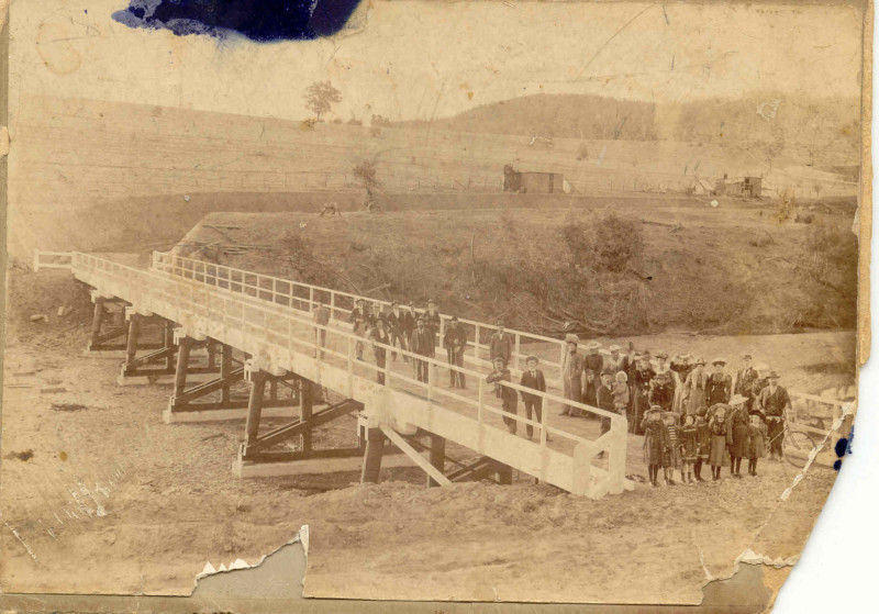
The Opening of the Darbys Falls Bridge over the Lachlan River in 1903.
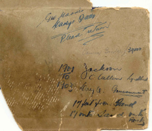
Notations on reverse of bridge photograph.
![Bridge at Darbys falls NSW [Canowindra Star and Woodstock Recorder Friday 2 May 1902.]](http://www.frankmurray.com.au/wp-content/uploads/2010/06/Bridge-at-Darbys-Falls.jpg)
Bridge at Darbys falls NSW [Canowindra Star and Woodstock Recorder Friday 2 May 1902.]
Darbys Falls School ca. 1883
This and the photograph below show the planned location of the Darbys Falls School at the time the location of the village changed from Milburn Creek in 1881. Thye land allocated was 2 acres at the northern end of the planned village.

The original Darbys Falls Catholic Church at the site of the present day cemetery.

The “new” Catholic Church, now converted and used as a family home.

Shop,House, Post Office at Darbys Falls Ca 1950.

Darbys Falls from the Air 1

The shop at Darbys Falls pre-war.